 Fraunhofer Institute for Wind Energy Systems
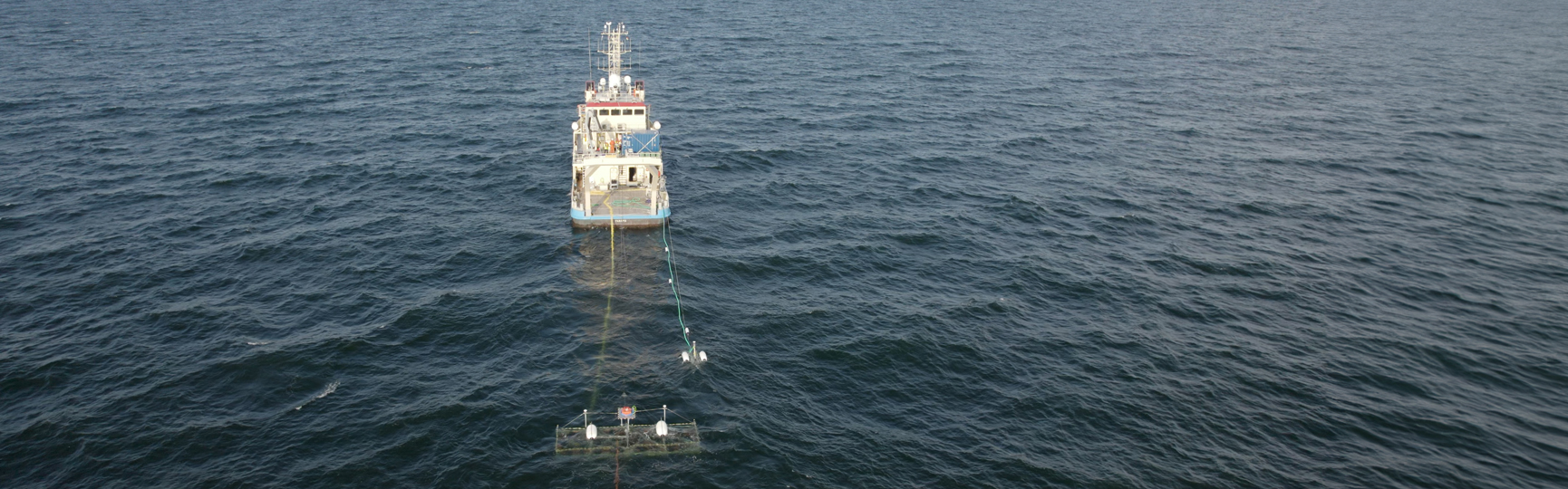
Fraunhofer IWES uses flexible surveying solutions to find the optimum subsoil for offshore wind turbines.
Innovative and efficient – seismic surveying of the offshore subsurface
Optimizing the seismic surveying of the future with innovative R&D
Advanced 2D/3D imaging and interpretation
High-resolution object detection by means of diffraction backscattering
Our services in Multichannel seismic survey of offshore subsoil
The assessment of geological subsurface conditions is indispensable for the planning and development of offshore wind farms. It represents the key to determining geotechnical design parameters for the foundation structures of offshore wind turbines. Boulders and other geological features can pose risks for their installation. Fraunhofer IWES has developed a range of multichannel seismic measuring methods specifically for use in shallow waters in the offshore wind industry. Among other things, it conducts comprehensive research and industry projects in the field of ultra high-resolution seismics and geological modeling. In addition, it operates a flexible 2D/3D UHR multichannel seismic system for the efficient creation of high-resolution ground models. A novel measuring system, which enables targeted risk assessment of offshore installation sites, represents another innovative technological development.
Fraunhofer IWES has developed a range of multichannel seismic measuring methods specifically for use in shallow waters in the offshore wind industry. Deployment of these methods has been commissioned in numerous offshore wind farm projects in the North Sea and Baltic Sea, delivering reliable results with success. IWES strives for continuous further development as regards optimization and increased efficiency for technical realizations of the seismic data collection and processing.
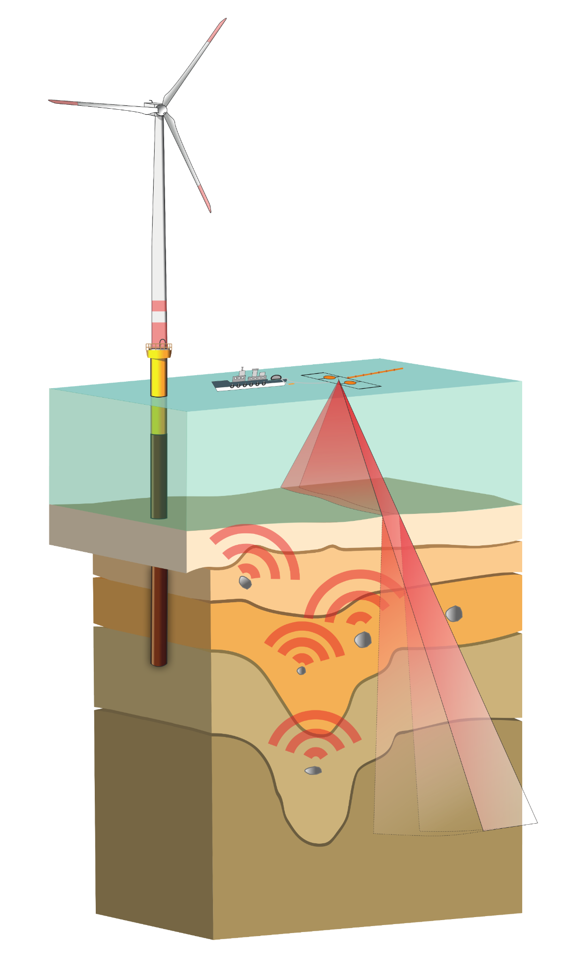
The novel measuring system, which opens up new possibilities in the targeted risk assessment of offshore installation sites, is a great example of the technological advances in this area. In combination with specially customized data evaluation, the system can map localized objects such as boulders in marine sediments up to the full depth of typical offshore wind turbine foundations. The system is based on multichannel seismic principles with an innovative hydrophone array system developed at the institute for data acquisition and a suitable high-frequency signal source (sparker). Whereas conventional seismic methods evaluate reflections from stratum boundaries in the subsurface, this system utilizes the weak but high-resolution diffraction backscattering originating from small objects in the subsurface. This makes it possible to localize objects at depths of up to approx. 100 meters below the seafloor in the shallow areas of the North Sea and Baltic Sea.
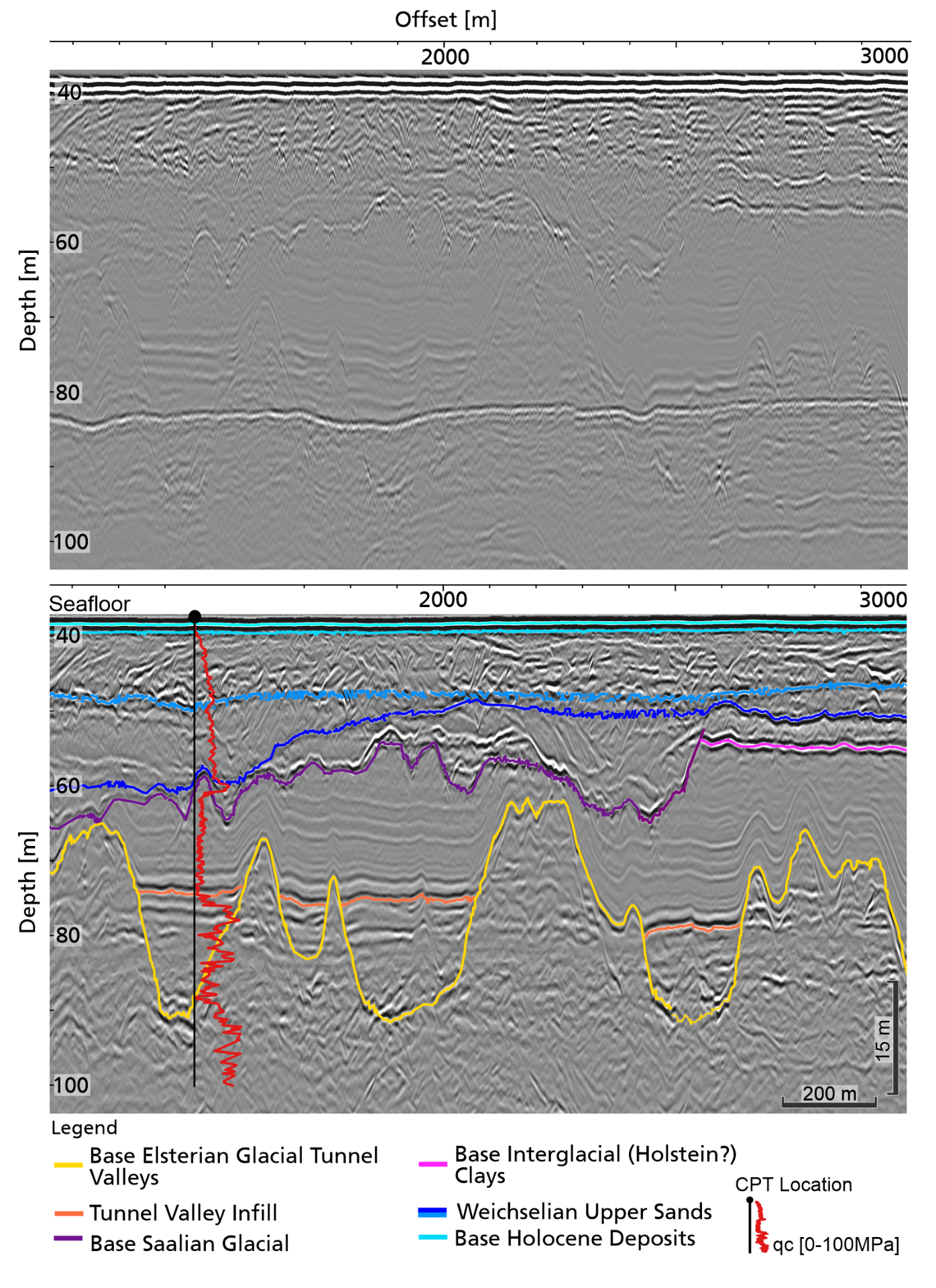
IWES conducts comprehensive research and industry projects in the field of ultra high-resolution (UHR/UUHR) seismics and geological modeling. It operates a flexible 2D/3D UHR multichannel seismic system developed specially for the surveying of offshore wind farm sites in order to enable optimal data collection, processing, and interpretation as a basis for the creation of ground models. The system comprises a single hydrophone streamer system optimized for UHR seismic measurements with sparker signal sources, a highly precise GNSS positioning solution, and special workflows developed by the institute for data handling, processing, and evaluation. IWES offers flexible surveying solutions and continuously improves seismic surveying techniques for the benefit of renewable energies in the offshore sector.

Rocks and other geological features (shallow gas deposits, cohesive strata) can pose risks during the installation of offshore infrastructures such as offshore wind turbines. Boulders in the sediment in particular can damage the ram piles during the installation of support structures. Possible abortion of the installation and longer delays can result in considerable costs for the wind farm developer. Precise knowledge of the subsurface geology (e.g., the location of the boulders) enables efficient micrositing, thus minimizing the installation risks. In parallel, current research is also investigating the aspects of cable detection (DoB) and UxO detection.
Fraunhofer IWES and the University of Bremen developed a novel data acquisition system specifically for the purpose of diffraction imaging and the localization of point diffractors (e.g., boulders) within marine sediments. The system’s specially designed recording geometry combined with the processing of synthetic apertures enables comprehensive ultrasound exploration of the survey site, resulting in excellent overall data coverage as well as time- and cost-efficient measurement campaigns.
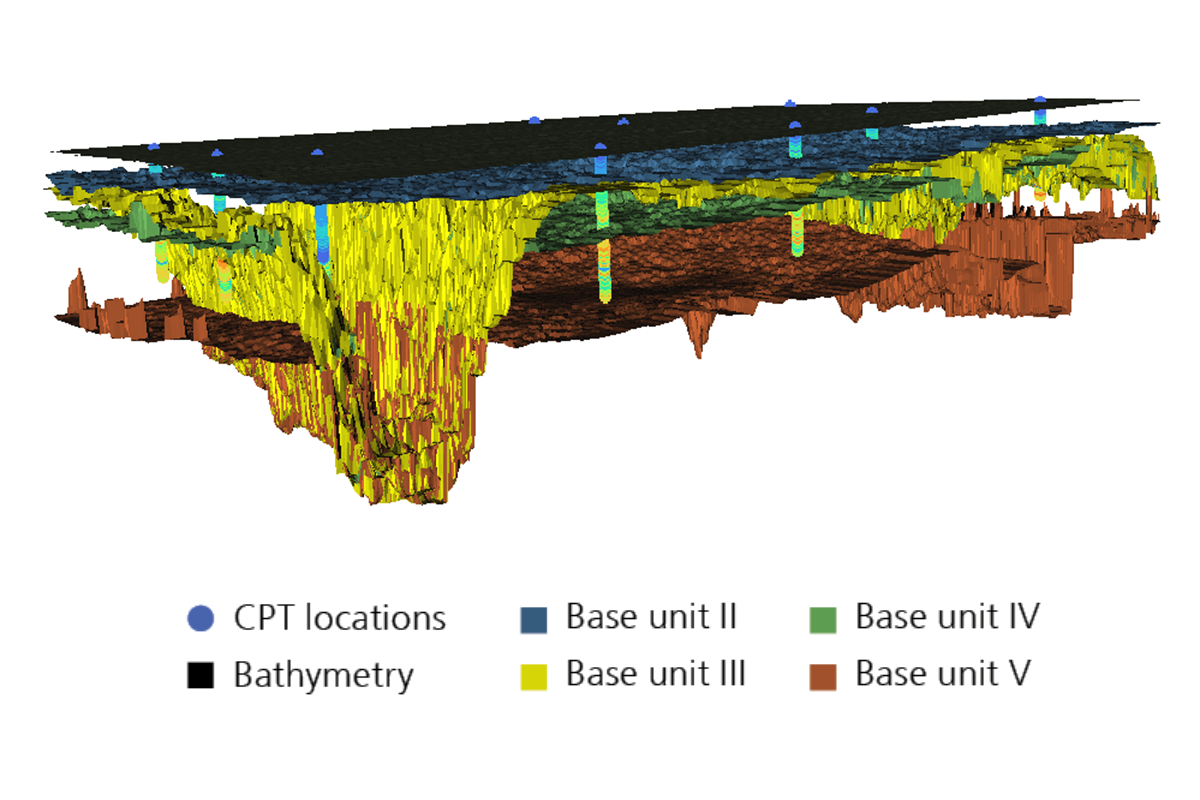
The assessment of the geological subsurface conditions is indispensable for the planning and development of offshore wind farms. The results of the geophysical surveys and the geotechnical campaigns need to be summarized and integrated to obtain a comprehensive understanding of the subsurface. This knowledge is the key to determining geotechnical design parameters for the foundation structures of offshore wind turbines.
IWES has been one of the world’s leading providers of offshore wind farm site surveys since 2019. On behalf of the Federal Maritime and Hydrographic Agency of Germany (BSH), it performed the preliminary geophysical surveys for all the wind farm clusters in German waters. During this time, IWES developed special workflows for the integration of geophysical and geotechnical data for ground modeling in an effort to minimize costs for industry. The integration of seismic UHR data sets including the evaluation of seismic attributes with high-quality geotechnical data enables the derivation of optimal, planning-relevant parameters. The IWES workflow taps the full potential of these integrated ground models. On the basis of this model, the geotechnical parameters essential for pile dimensioning are available for every possible wind turbine site in the surveyed area, thus enabling the plans to be adapted as flexibly as possible to evolving wind farm layouts.